
Where to follow the events at the front/Headquarters of the JFO
Russia continues the war against Ukraine. In some sectors of the front, the situation is constantly changing. You can follow the developments of the Russian-Ukrainian war online on special maps.
On different maps, you can track the course of hostilities in Ukraine from the very beginning of Russia's attack on Ukraine on February 24, 2022.
Channel 24 has collected key services that allow you to track the progress of hostilities in different parts of the country in real time.Important! These maps cannot be used to plot evacuation routes. Despite the accuracy of the work of these services, the delay in updates is sufficient to endanger the lives of those who want to escape from the war zone along the way.
Liveuamap
The Liveuamap online map system, developed by Ukrainian programmers from Dnipro, allows you to live follow the course of military conflicts around the world.
The impetus for the creation of the project was the events of the Revolution of Dignity. The authors wanted to give people the opportunity to distinguish fact from fiction by noting the positions of government forces and protesters on the streets of Kyiv. Initially, the service was built on the basis of interactive Google Maps. After the start of Russian aggression, he covered the invasion of Crimea and the course of the war in Donbas.
When the intensity of hostilities in the Donbass decreased, the developers decided to cover the situation in other hot spots of the world. From a certain point, the developers switched from Google Maps to creating their own maps based on the Open Street Map.
After a few years, Liveuamap had a number of maps of wars and protests on every continent of the planet. Liveuamap data has been used by Western foreign ministries and humanitarian missions, including mine clearance and rescue missions.

Map of the fighting from Liveuamap/Screenshot
Since 2022, the project has covered the progress of Russia's full-scale invasion of Ukraine. From the Liveuamap map, you can get information about the shelling of Ukrainian cities, military operations in different sectors of the front, downed Russian missiles or drones, road closures in frontline areas.
DeepStateMapLive
This map was created by the DeepStateUA team at the beginning of the Russian invasion of Ukraine in February 2022 to inform the progress of the military operations.
Initially, the service worked on the basis of Google Maps, but after the attacks of the Russians, the map was blocked. After that, the development team decided to create their DeepStateMAP site, which went live on March 27, 2022.
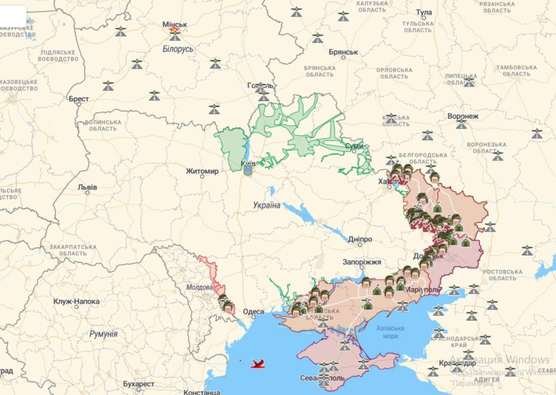
Map of hostilities and deployment of enemy forces by DeepStateUA /Screenshot
In addition to information about the settlements occupied and liberated from the Russians, here you can find data on the location of enemy units and headquarters, as well as the deployment of some of its resources.
Map of hostilities in Ukraine of the Institute for the Study of War (ISW)
The ISW interactive map is the most popular among military experts and the world's media.
The Institute for the Study of War is one of the world's most respected think tanks that studies long-term military conflicts. Actually, ISW's forecasts for the development of the Russian-Ukrainian war were the most accurate. Unlike statements by various analysts who predicted that Ukraine would not last longer than 3 days in the war against Russia.

Warfare map from the Institute for the Study of War /Screenshot
The ISW constantly monitors the situation on the front in Ukraine, analyzes information received from sources on both sides, and publishes daily reviews assessing the Russian invasion on the main directions.
War Mapper
This analytical project visualizes exploration results based on open data based on Soar.earth maps.
In social networks, War Mapper analysts outline the latest changes in the course of the events of the Russian-Ukrainian war. Of the unique sights, there are time-lapses that clearly show how the situation at the front has changed.
Thus, for example, the last such video shows that the Russian offensive reached its peak on the 23rd day of the invasion. After that, enemy activity changed.
Ukraine Battle Map
Another project created by a team of OSINT analysts from Ukraine and the USA. In their work, they are based on data from various sources, including information from the defense departments of Britain and the United States.
In addition to maps updated around the clock, the project also produces analytical reports describing key changes in the situation in each region over the past 24 hours . The project participants keep in touch with people in the occupied territories in order to better understand the current situation and check the information.
Map from the British Ministry of Defense The department on its Twitter page also regularly publishes updates to the map of hostilities in Ukraine. It features up-to-date information on the Russian offensive in Ukraine, based on the latest data from the US Department of Defense.
In addition to the maps, the page also regularly features fresh intelligence reports on the progress of Russia's “illegal and unprovoked” large-scale invasion of Ukraine.< /p>
Also, visualization of the latest information from the Ukrainian fronts can be found on the pages of various media and public organizations.