The Ukrainian Armed Forces entered Vnezapnoye in the Kursk region: where the village is on the map and what is the distance to Ukraine Dmitry Usik Village of Vnezapnoye, Kursk Oblast/Collage by Channel 24 On Wednesday, August 14, it became known that the Armed Forces liberated several more settlements in the Kursk Oblast. In particular, the military removed the Russian flag in the village of Vnezapnoye. In addition, the Defense Forces cleared the neighboring villages of Viktorovka and Gordeyevka. The location of these three settlements on the map is shown by Channel 24. On the ninth day of fighting in Kursk Oblast, it became known that the Armed Forces took control of at least three more villages – Vnezapnoye, Viktorovka and Gordeyevka. All of them are located in the Korenevsky district of Kursk region and lie near the border with Ukraine – the distance to Sumy Oblast is less than 4 kilometers. It should also be noted that the distance to the city of Korenevo itself is 20 kilometers, and to Sudzha – only 35. < p > < strong > Where is Vnezapnoye and other liberated villages located: see the map < p > Let us add that a direct road to the village of Snagost runs past these villages, and from there – to Korenevo itself. < p > By the way, Alexander Syrsky said during his morning report on August 14 that at the beginning of the day a hundred Russians were captured in the Kursk region. It was also noted then that Ukrainian troops advanced in certain directions from 1 to 2 kilometers. According to Syrsky, the “search and destruction of the enemy in the settlement of Sudzha” was also completed.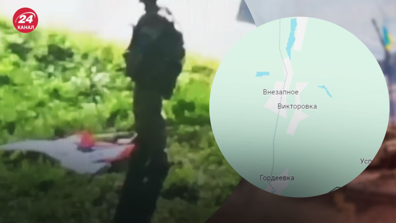
Operation in Kursk Oblast
The Ukrainian Armed Forces entered Vnezapnoye, Kursk region: where is the village on the map and what is the distance to Ukraine

54