
The full-scale war in Ukraine began at about 05:00 on February 24, 2022, by order of Russian President Vladimir Putin.
The invasion started with an attack on airfields, military warehouses in Kyiv, Kharkov and Dnieper, as well as on the state border in the area with Russia, Belarus and occupied Crimea.
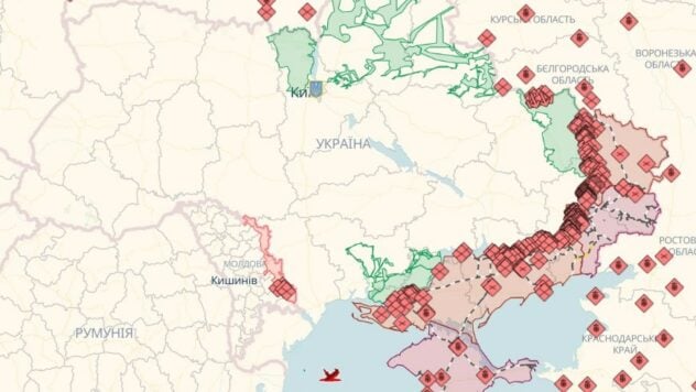
ICTV Facts offer battle maps from Deep State, Institute for the study of war and CTP, which conditionally display the situation in the cities of Ukraine. Also available is a battle map liveuamap.com.
Now watching
Deep State's online map of military operations in Ukraine
Mark symbols:
- blue areas – the territory from which the invaders were driven out;
- green areas – territory liberated at the end of March – beginning of April;
- gray areas – area requiring clarification;
- red areas – territory captured by the occupiers;
- black color – territory of Crimea and ORDLO;
- pink color – territory of Transnistria.
Also on the Deep State map are enemy units, headquarters, airfields, fleet and attack directions of the occupiers.
Never use the map to find safe routes, use the green corridors suggested by the authorities.
Combat map liveuamap.com
On the map you can see online where the fighting is going on in Ukraine, which territories are already free from the invaders and other important events.
Color symbols on the map:
- blue – Ukrainian government, NATO, other Western forces;
- red – Russia, Belarus, Transnistria.
The areas on the map marked in red are temporarily occupied territories of Ukraine.