On February 24, 2022, a new page in the history of Ukraine began, full of pain and loss. Russian occupiers, not shying away from any methods, attack peaceful cities and villages, turning them into ruins. Maternity hospitals, schools, residential areas – everything becomes a target for enemy missiles. Every day, Ukrainians are forced to hide in shelters, escaping from shelling. We suggest tracking these terrible statistics and remembering the price Ukraine is paying for freedom.
ICTV Facts found out how many alarms there were in Ukraine in 2024 and residents of which regions were most often forced to go into shelter.
How many alarms sounded in Ukraine in 2024
The total number of alarms in Ukraine in 2024 — more than 21,605 times. Data from January 1, 2024 to the end of December 30, 2024 only from official sources.
Now watching
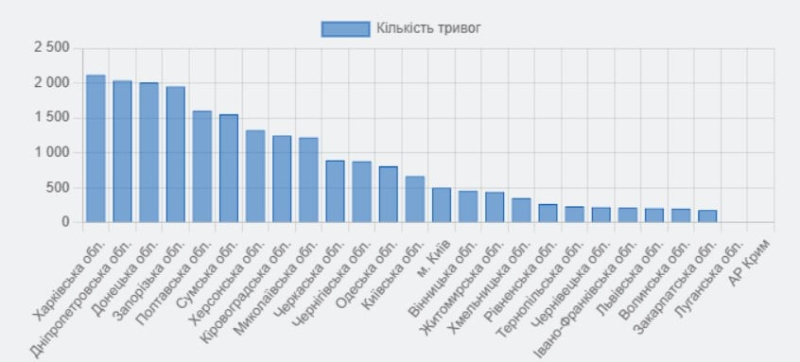
The largest number of alarms were sounded in Kharkiv, Dnipropetrovsk, Donetsk and Zaporizhia regions.
“The leader” in the number of air raid alarms is Kharkiv region: 2,119 alarms were sounded here in 2024. The data is provided from January 1, 2024 to the end of December 30 inclusive.

Screen: Air-alarms.in.ua: Number of alarms

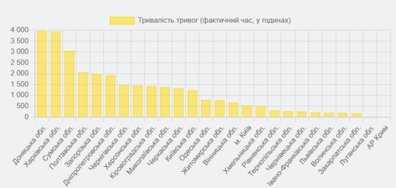
Screenshot: Air-alarms.in.ua: Alarm Trip
In the city of Kyiv 500 warnings about threats were sounded in 2024. The average duration of alarms in Ukraine was 1 hour 29 minutes 7 seconds. The longest alarm sounded in 2024 in the Kharkiv region. It lasted 50 hours 31 minutes 18 seconds. It was announced on July 23, 2024 at 18:31.
Also, one of the leaders in the number of warnings about the threat of strikes can be considered the Dnipropetrovsk region. In the Dnipropetrovsk region in 2024 (up to and including December 30), 2036 air raid alarms were sounded. In particular, in the Dnipropetrovsk region, the threat of artillery shelling was announced more than 10,345 times.
The largest number of explosions were recorded in the Sumy, Kherson and Donetsk regions.
To find out about the presence of warnings, you can use the Air raid map. It is an online platform that is updated every 25 seconds.
It uses geodata to visualize regions where air raid sirens are sounding. The map is color-coded to clearly show the threat level in each region. Red indicates a high probability of missile attacks or airstrikes, gray/black — no threat, and white/light gray — for lack of current information.
Source: Airs-alarms.in.ua

